volcano is a vent or chimney which transfers molten rock (known as magma) from depth to the Earth’s surface through eruptions. Magma erupting from a volcano is called lava. Lava builds up around the vent and forms a cone.
A volcano is currently active if it is erupting lava, releasing gas or generating seismic activity. An active volcano is labelled dormant if it has not erupted for a long time but could erupt again in the future. When a volcano has been dormant for more than 10 000 years, it is considered extinct. Volcanoes can remain inactive, or dormant, for hundreds or thousands of years before erupting again. During this time, they can become covered by vegetation, making them difficult to identify.
How explosive a volcanic eruption is depends on how easily magma can flow or trap gas. If magma is able to trap a large amount of gas, it can produce explosive eruptions.
Volcanoes can have many different appearances. Some volcanoes are perfect cone shapes while others are deep depressions filled with water. The shape of a volcano provides clues to the type and size of eruption that occurred. Eruption types and sizes depend on what the magma is made up of. Three common volcano forms are:
Shield volcano
Shield volcanoes have a broad, flattened dome-like shape created by layers of hot and runny lava flowing over its surface and cooling. When magma is very hot and runny, gases can escape easily. Eruptions of this type of magma are gentle, with large amounts of magma reaching the surface to form vast lava flows.
Because the lava flows easily, it can move down gradual slopes over great distances from the volcanic vents. The lava flows are slow enough for humans to outrun or outwalk them. This type of magma ranges in temperature between 800 °C and 1200 °C and is called basaltic magma.
Examples of shield volcanoes in the Asia-Pacific region include Taveuni Volcano in Fiji, Dunedin Volcano in New Zealand and Tweed Volcano in Australia.
Composite volcano (Strato)
Also known as strato-volcanoes, composite volcanoes are formed from explosive eruptions. These eruptions create steep sided cones.
When magma is slightly cooler it is viscous (thick and sticky), which makes it harder for gas bubbles to expand and escape. The magma in these eruptions has higher silica content than the magma that forms shield volcanoes. When there is high concentration of silica in lava, the silica molecules link together by sharing oxygen atoms. These bonds are very strong and make the liquid magma act more like a solid.
Examples of composite volcanoes in the Asia-Pacific region include Mayon and Pinatubo volcanoes in the Philippines, Tambora, Merapi and Sinabung volcanoes in Indonesia and Mount Ruapehu and Mount Taranaki in New Zealand.
Caldera volcano
These volcanos erupt so explosively that little material builds up near the vent. Eruptions partly or entirely empty the underlying magma chamber which leaves the region around the vent unsupported, causing it to sink or collapse under its own weight. The resulting basin-shaped depression is roughly circular and is usually several kilometres or more in diameter. The lava erupted from caldera volcanoes is very viscous and generally the coolest with temperatures ranging from 650 °C to 800 °C and is called rhyolitic magma. Although caldera volcanoes are rare, they are the most dangerous. Volcanic hazards from this type of eruption include widespread ash fall, large pyroclastic surges and tsunami from caldera collapse.
Examples of caldera volcanoes in the Asia-Pacific region include Rabaul Volcano in Papua New Guinea and Krakatoa Volcano in Indonesia.
Volcanic hazards
Volcanic hazards include explosions, lava flows, bombs or ballistics, ash or tephra, pyroclastic flows, pyroclastic surges, mudflows or lahars, landslides, earthquakes, ground deformation, tsunami, air shocks, lightning, poisonous gas and glacial outburst flooding known as jökulhlaups. Each hazard has a different consequence, although not all occur in all eruptions or in association with all volcanoes.
Volcanic eruptions are measured using a simple descriptive index known as the Volcano Explosivity Index (VEI) which ranges from zero (non-explosive) to eight (catastrophically explosive). The index combines the amount of material ejected (by volume) with the height of the eruption column and the duration of the eruption.
Volcanic activity frequently occurs at the boundaries of the Earth’s tectonic plates. The movement of these plates plays a significant role in the type of volcano formed, which influences its shape.
Spreading plate margins
Areas of the Earth where plates move away from each other are called spreading or divergent plate margins. In these areas, volcanic eruptions are usually gentle extrusions of basaltic lava. Most of these eruptions occur underwater where magma rises from great depth below to fill the space created by seafloor spreading. This occurs at a rate of about 10 centimetres a year.
Subducting plate margins
At subducting plate margins, one plate is pushed under a neighbouring plate as they squeeze together. In these margins, wet sediment and seawater is forced down in addition to the old, weathered plate. The addition of this sediment and seawater creates andesitic lava and more violent eruptions containing ash. These volcanoes form classic cone shapes.
Hotspot volcanoes
Locations of anomalous volcanism (i.e. forming at great distances from plate boundaries) are commonly referred to as ‘hot spot’ volcanoes. There are two currently debated explanations of how this volcanism is generated:
from hot mantle upwellings or plumes which rise from great depth (hence the term ‘hot spot’)
from passive rising of melt from shallow depths that is not actually anomalously hot.
Examples include Hawaii, Iceland and Yellowstone. If the plate overlying the plume moves away from the hot spot, a new volcano can be formed. The previous volcano cools to become dormant and eventually extinct. This sequence forms a volcanic chain such as with the Hawaiian Islands
Sometimes volcanoes can be two types. Iceland is an example of a volcano that falls into two categories. It is a spreading plate margin volcano as well as a hotspot volcano.
Volcanoes in Australia
Active volcanoes generally occur close to the major tectonic plate boundaries. They are rare in Australia because there are no plate boundaries on this continent. However, there are two active volcanoes located 4000 kilometres south west of Perth in the Australian Antarctic Territory: Heard Island and the nearby McDonald Islands.
The other active volcanoes nearest Australia are in Papua New Guinea, New Zealand, Indonesia and the Philippines. Gas-rich sticky magmas dominate the Asia Pacific, making composite volcanoes and calderas the most common varieties in the region. These types of volcanoes severely threaten lives, property, agricultural lands and lifelines throughout south east Asia and the Australian region.
Evidence for volcanism throughout geological time can be found in every Australia state and territory, with extensive volcanism down the east coast during the past 60 million years. This volcanic activity can be divided into areas where large amounts of lava flowed from dykes and pipes over a wide area and others where volcanism was produced from either a single central vent or a cluster of vents.
It is thought that the central volcanoes were produced as the Australian continent moved over a hot spot in the underlying mantle which melted through the plate to form the volcano. As the continent moved northward, the stationary hot spot formed volcanoes further to the south on the continent. As a result, the rocks of central volcanoes down the east coast become younger as you move southward.
Predicting eruptions
Understanding how volcanoes work and how their eruptions can be predicted is essential for the well-being and preservation of people who inhabit volcanically vulnerable areas. Eruptions can occur without any preceding signals, making them extremely difficult to predict. However, sometimes there are useful clues for judging when a volcano is likely to erupt.
A volcano’s eruptive history can provide some clues. However, because only a small number of the world’s volcanoes have a known history it is extremely difficult to predict future eruptions, particularly for certain types of volcanoes. Scientists use the repose period, or the time between eruptions, to indicate the expected size and strength of an eruption. Consistently long repose periods may indicate that a volcano’s eruptions are usually large and explosive. However, sometimes there is no clear relationship in the length of time between eruptions and the nature of the eruptions.
Earthquake activity around a volcano can provide valuable information. An eruption can be preceded by hundreds of small earthquakes know as earthquake swarms. Earthquakes also can indicate that magma is moving beneath a volcano. However, eruptions can occur with no perceivable change in seismic activity.
Small changes in the shape of a volcano such as bulging may indicate that magma is rising. Accurately measuring the summit and slopes of a volcano is one of the most important tools used for forecasting an eruption. Temperature changes in surface lakes or the groundwater near a volcano also can be a valuable early detection tool, although not all large changes in temperature are related to volcanic eruptions.
Gases emitted at, or near a volcano may show that a magma chamber is refilling or that a new type of magma is rising from depth. Changes in the volume or type of volcanic gases produced also may be an indicator of magma activity.
Volcanic ash clouds can damage aircraft engines but ash is not visible by radar, the main navigation aid for aircraft. There are nine Volcanic Ash Advisory Centres around the world which use satellites to help track volcanic ash clouds and provide warnings for aircraft. The Bureau of Meteorology operates Australia’s Ash Advisory Centre.
On average, one or two eruptions each year worldwide originate from volcanoes with no previous historical activity or after being dormant for thousands of years. The most violent eruptions occur after long periods of inactivity. Eruptions from these types of volcanoes represent some of the worst natural disasters.
The interior of many volcanoes stay hot for a long time. This heat can warm underground water in the vicinity of the volcano. The heated water then reaches the surface to form geysers, fumaroles, bubbling mud pools and hot springs. They also create occurrences of sulphur and other mineral deposits.
There is a volcanic province in southeast Australia called the Newer Volcanics Province, which is a collection of volcanoes (almost 400) covering a 15 000 square kilometre area. The most recent eruptions were around 5000 years ago at Mount Schank and Mount Gambier. The area is considered dormant, which means it is not currently active, but could become active at any time.
There are also active volcanoes located 4000 kilometres south west of Perth on the Australian territories of Heard Island and McDonald Islands. There have been several eruptions in recent years, however, these eruptions have not affected mainland Australia.
Volcanic eruptions are measured using a
Author Archives: Makame Haji Ali
CONTINENTAL DRIFT (PHYSICS)
CONTINENTAL DRIFT AND PLATE TECTONIC THEORIES
1)CONTINENTAL DRIFT THEORY
This theory was first conceived by scholars and philosophers like Francis Bacon, George Buffon and Alexander Von Humboldt.
The concept say that the continent once had fit together but has driftted apart after millions years.
Then later later German meteorologist and geophysicist Alfred Wagner (1880-1930).
In 1912 spent much exploration and research to prove the theory of continental drift,
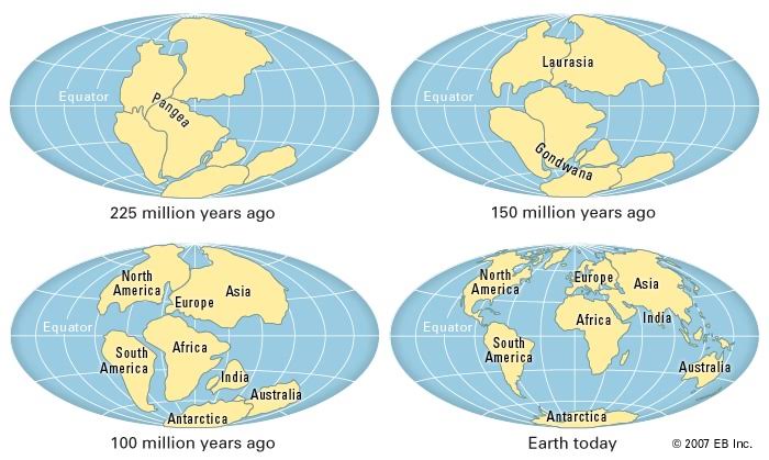
According to his theory” About 225 – 280 millions years ago,the present day continent ware united in a single block called Pangea and sorrounded by ocean called Panthalassa .
The Pangea was located near the south pole.
Later Pangea split into two super continent ie Gondwanaland (South pole) and Laurasia(Along equator in northern hemisphere).The two super continent ware separated by narrow water body called Tethys sea
He assert that the Laurasia split to form North America , Asia , Europe and numerous land mass in Northern hemisphere such as Green land, Ice land and UK . &
Gondwanaland split to give present day South America, Africa, Australia, Antarctica, Indian sub-continent and other islands in southern hemisphere.”
This can be illustrated by digram below.
NOTE
Since a time continent have been drifting apart to occupy their present position , the drift is very slow about 2 cm/year (The drifting still progress ).
EVIDENCE TO SUPPORT WEGNER CONTINENTAL DRIFT THEORY.
-Structural evidence (Jigsaw fit):If continent ware brought together it will form one single land mass ie S.America , Sub-continent , Antarctica and Australia into Africa can fit to form single land mass . Also N.America fit in Europe and Asia.
-Geological evidence: Similar rocks in coastal margin of coastal continent Example:The rock of West Africa are similar interm of structure and formation to those of eastern coast of Brazil .
– Biological evidence:The study of fossil reveal that,the similar fossil of different time ware found in different place (ie similar animals and plants and other fossils are found in different continent).
-Paleo-magnetic evidence:This was done through Paleo-magnetic dating.When a rock heated and cooled they ware magnetized in same direction,but also show that rock from different part of the earth have shifted relative position magnetic field new path represent relative migration.
-Geomorphologic evidence:The different mountain in Africa and Europe show have same structure, formation Example . Structural formation of of fold mountain like Alps and Atlas mountain all are formed In Africa and one move nortword due to drift.
-Paleoclimatic evidence .
CRITIQUE OF CONTINTAL DRIFT THEORY.
-Alfred Wagner meddled in the field of geology: Haven’t enough knowledge to explain about geology as far he was dealing with meteorology.
– Misfit of some continent: Possibly not all continent fit exactly to each other if they could brought together.
-Wagner fail to explain the mechanism of drifting continent:The actual force which causes the drifting proces wasn’t explained clearly by Wagner.
– Wagner didn’t explain the development of glaciers in hot region of Australia.
IMPACT OF CONTINENTAL DRIFT
-Climatic change
-Land form formation like Rift valley,sea, ocean and mountain.
-Occurance of earth quake and Volcanic eruption.
2-PLATE TECTONIC THEORY.
This is the modern theory which come to explain the plate continental drift theory.
That term tectonic plate made up by two terms ie
Plate-the slab of solid rock
Tectonic- Greece word means to build
Therefore,
Plate tectonics is the theory that say earth lithosphere is made up by individuals plate that are broken down into over dozen large and small pieces of solid rock.
The piece of solid rock (plates) are large continental and oceansized plate, six or seven medium sized plates and several small ones.
Seven major plate are North America, South America, Eurasia, Africa,Indo-Australia, Pacific and Antarctica, as well there is many smaller pale (microplate) such as Juan De Fuca near Washington in USA.
The plate move relative to each other at rest of 5-10 cm/year and interact along the boundaries.
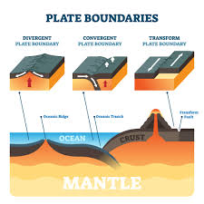
TYPES OF BOUNDARIES
i) Divergent boundary: This occur when two tectonic plates move away from each other.
In this boundaries there is high possibilities of occurrence of earth quake and Volcanic eruption.
The movement of this plate can produce feature like Rift eg Rift valley and oceanic ridges.
Example o of the boundaries are Mid-Atlantic ridge and Pacific ring of fire.
ii) Convergent boundaries:This occur when two plates come together.
In this boundaries the edge of the both plates buckle up into a mountain ranges or plates bend down into a deep sea floor trench.
The impact on this boundaries are destruction of oceanic crust , occurrence of a Chain of volcanoes, powerful earthquake and Trench like Mariana trench.
Examples of this boundaries are
iii)Transform boundary: In this boundaries two plates slide each other. The impact of this boundaries are
Example of this boundarie is San Andreas zone in USA which extended under water.
The digram below show types of boundaries.
CAUSE OF PLATE TECTONIC MOVEMENT..
1) Convectional curent: Convectional movement of magma in the mantl cause , some of magma to move laterally below lithosphere , the lateral movement drag the lithosphere leading the plate tectonics movement
2) Upwelling of magma:In the lines of weaknes like Mid-oceanic ridge the magma rush out cause the movement of plate.
3) Isostatic movement: This slight movement of plate when trying to create balance cauae plate movement.
4) Cooling and heating of the crustal rock.
EFFECT OF PLATE TECTONIC MOVEMENT
Effect/Impact of Plate tectonics is just like continental drift ie
-Formtion of Rift like Rift valley caused by weak divergent movement of plate.
-Formtion of mountain
-Formtion of trench like Mariana trench in Pacific
-Occurance of earthquake and Volcanic activities.
.
